~Watering the West since 1926.~
About Us
What we do
The Boise Project furnishes a full irrigation water supply to 167,000 acres through the New York Canal and the Mora Canal with over 460 other canals and laterals equal some 1,500 miles of canals and drains. The irrigable lands are in southwestern Idaho and eastern Oregon.
Principal facilities include five storage dams (excluding Lucky Peak Dam constructed by the Corps of Engineers and Hubbard Dam a reregulatory facility) which form reservoirs with a total capacity of 1,793,600 acre-feet (active 1,663,200 acre-feet), two diversion dams, three powerplants with a combined capacity of 50,200 kilowatts, seven pumping plants, canals, laterals, and drains.
To facilitate organization of the administrative and operating procedures, the irrigable project lands are divided into the Arrowrock and Payette Divisions. Some of the features serve only one division; other features serve both divisions as well as other nearby projects.
Useful Links
Learn about the New York Canal
Idaho Statutes: Title 42 Irrigation and Drainage - Water Rights and Reclamation
Idaho department of Water Resources
Join us! See our Job Openings.
Arrowrock Diversion Canal System
The New York Canal is about 40 miles long and has a diversion capacity of 2,800 cubic feet per second. It consists of the enlarged old New York Canal, a section of new canal, and a part of the channel of Indian Creek. Diversions are made from the New York Canal into various canals such as the Mora Canal and the Deer Flat High Line Canal and into numerous distribution systems. Water delivered by the New York Canal to Lake Lowell is diverted into the four canals outletting the reservoir.
History
Boise Project Board of Control is the operating agent for five irrigation districts: Boise-Kuna Irrigation District, Big Bend Irrigation District, Nampa & Meridian Irrigation District, New York Irrigation District, and Wilder Irrigation District. Its purpose is to manage the irrigation facilities and other works transferred by the United States Bureau of Reclamation to these five irrigation districts and to deliver water to their landowners. These facilities are referred to as "transferred works" and include all of the facilities beginning at Diversion Dam on the Boise River, and including the New York Canal, the embankments at Lake Lowell and approximately 1500 miles of canals, laterals, and drains. Title to the "transferred works" remains in the United States.
Boise Project Board of Control was created in 1926 by virtue of contracts entered into between these five irrigation districts and the United States. The contracts were approved by the voters of the five irrigation districts and confirmed by the courts.
Prior to 1926, the United States Bureau of Reclamation had constructed the Arrowrock Dam, taken over the New York Canal and completed it to Lake Lowell, constructed other canals, and dug drains. The operation and maintenance of these facilities are the responsibility of the Boise Project Board of Control, with the exception of Arrowrock Reservoir which continues to be operated and maintained by the United States Bureau of Reclamation. In 1941, the Districts entered into contracts with the United States Bureau of Reclamation for additional water stored behind Anderson Ranch Dam. Those contracts were also approved by the landowners and the courts. As a result, the Boise Project Board of Control now delivers both natural flow water rights and approximately 85% of the water stored behind Arrowrock and Anderson Ranch Dams to the landowners of the five irrigation districts. Boise Project Board of Control delivers water to approximately 167,000 acres of irrigated land within these five irrigation districts, primarily on the south side of the Boise River, and also delivers water to land from the Penitentiary Canal on the north side of the river located east of the city of Boise. Boise Project Board of Control delivers water to pressurized irrigation systems within the Districts and operates on the Districts' behalf over 35 pressurized irrigation systems.
Boise Project Board of Control is governed by a Board of Directors. Membership on the Board is established by the contracts between the Districts and the United States. Representation on the Board is based upon the number of acres within the Boise Project. Wilder Irrigation District has three (3) members, Boise-Kuna Irrigation District and Nampa & Meridian Irrigation District have two (2) members each, New York Irrigation District has one (1) member, and Big Bend Irrigation also has one (1) member. Boise Project Board of Control has a manager to run the transferred works and currently has approximately one hundred employees on staff dedicated to delivery and tracking of water throughout the 167,000 acres.
In 2010, the Districts, as licensees under license issued by the Federal Regulatory Commission, began in operation of the Arrowrock Hydroelectric Plant located at Arrowrock Dam. Boise Project Board of Control operates the hydroelectric plant under contract with the Districts. Cost of operation of the hydroelectric plant is covered by revenues from generation, not by assessments to the landowners.
Anderson Ranch Dam and Powerplant
Anderson Ranch Dam and Powerplant is a multiple purpose structure that provides benefits of irrigation, power, and flood and silt control. Situated on the South Fork of the Boise River 28 miles northeast of Mountain Home, the dam is 456 feet high, was the world`s highest earthfill dam at the time of its completion in 1950, and has a total storage capacity of 474,900 acre-feet (active 413,100 acre-feet). The power plant had a rated capacity of 27,000 kilowatts with two units installed. These units were uprated in 1986, increasing the capacity to 20,000 kilowatts each for a total of 40,000 kilowatts.
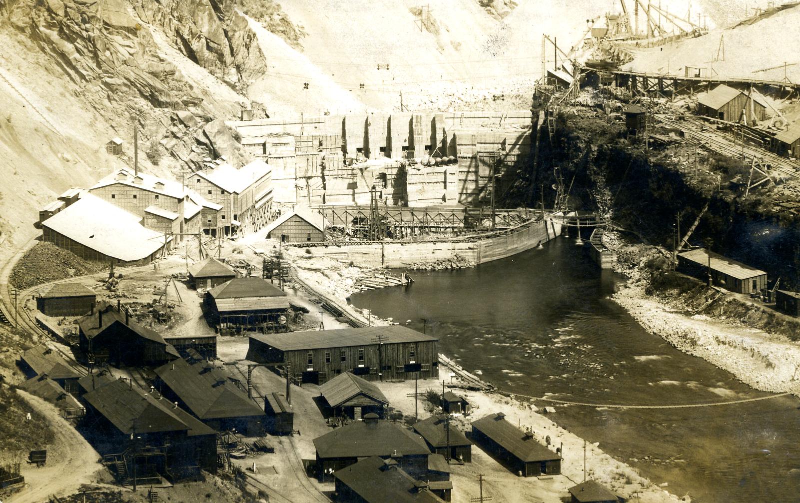
Arrowrock Dam
Arrowrock Dam, on the Boise River, 42 miles downstream of Anderson Ranch Dam and 22 miles upstream from Boise, is a concrete thick-arch structure 350 feet high. When constructed in 1915, the dam was recorded as being the tallest concrete dam in the world. The structure was repaired and raised 5 feet during 1935-1937, increasing its storage by 9,000 acre-feet; total storage capacity 286,600 acre-feet (active 286,600 acre-feet). The original construction involved the use of a rather high proportion of sand cement, and by 1935 the concrete on the downstream face of the structure showed deterioration due to climatic conditions. Repairs included refacing the downstream face and spillway channel. After 85 years of service, the Ensign valves had reached the end of their useful life. The lower set of ten Ensign valves were removed and replaced with clamshell gates between 2001 and 2004. A contract to permanently plug all five sluice gate outlet conduits was completed in January 2011.
A sedimentation survey completed in 1997 estimated the total capacity of Arrowrock Reservoir at 272,200 acre-feet (active 271,700 acre-feet).
The Boise Project Board of Control completed construction of a 15 MW powerplant at Arrowrock Dam in March 2010. The powerplant penstockes tie into two of the existing 66" outlet conduits. The project also updated the transmission line to the dam.
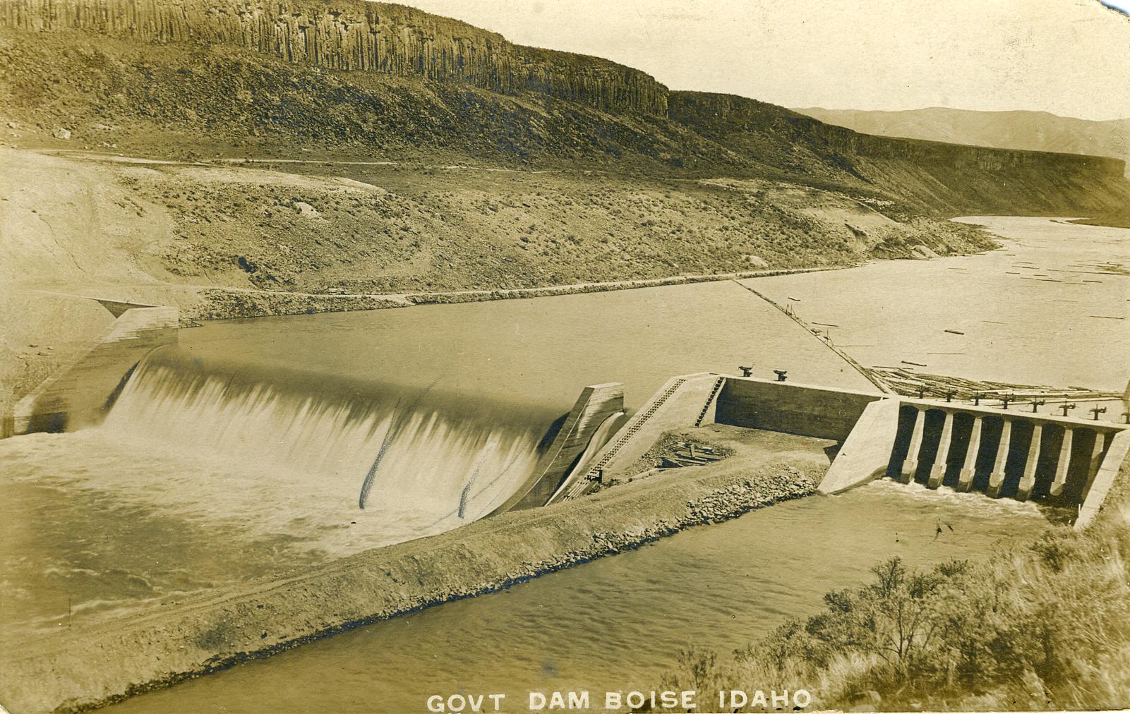
Boise River Diversion Dam Powerplan
The Boise River Diversion Dam, on the Boise River about 7 miles southeast of Boise, Idaho, is a rubble-concrete, weir-type structure with a hydraulic height of 39 feet. The dam diverts water into the New York Canal which serves distribution laterals and feeds Lake Lowell. A small canal known as the Penitentiary Canal, also originating at the diversion dam, distributes water on the north side of the Boise River to a small area of land east of Boise. The powerplant consists of three 500-kilowatt units that began operation in 1912. Due to the deteriorated condition of the equipment and high operating costs resulting from full-attended operation, the powerplant was placed in ready reserve status in 1982. The plant was reconstructed from 2002 to 2004 and returned to service in June 2004. The nameplate rating for the plant was increased from the original 1500 kW to 3300 kW. The existing double turbine configuration was retained, but refurbished with new materials and technology. Modern generators were installed inside the original generator housings.
Lake Lowell
Lake Lowell, originally known as Deer Flat Reservoir, is an offstream reservoir formed by three earthfill dams enclosing a natural depression southwest of Nampa, Idaho. These three dams are the Upper, Middle (Forest Dam), and Lower Embankments. A fourth embankment, called the East (Roadway Dike) is to protect farmsteads on the eastern end of the reservoir when the reservoir is full. The reservoir is filled primarily during the non-irrigation season by diversions at the Boise River Diversion Dam and conveyance through the New York Canal which discharges into the eastern (upper) end of Lake Lowell.
The Upper Embankment on the north side of the reservoir is 74 feet high and has two outlets; near the right abutment the Deer Flat Nampa Canal (100 cubic feet per second) and near the left abutment the Deer Flat Caldwell Canal (70 cubic feet per second).
The Lower Embankment at the west end of the reservoir is 44 feet high. The Deer Flat Low Line Canal (1,200 cubic feet per second) outlets on the left abutment and the Deer Flat North Canal (70 cubic feet per second) outlets on the right abutment.
The Middle Embankment, which has no outlets, is 16 feet high and helps to close the reservoir near the Lower Embankment. It has been referred to as an emergency spillway; however, no slope protection is provided for this purpose.
Because of safety concerns at the Upper and Lower Embankments, the maximum water level was reduced by 5 feet in 1989 while plans were prepared to address remedial actions. Major modifications were made to the Upper and Lower Embankments from 1991 to 1993. Further, in 1996 an upstream seepage blanket was constructed at the right abutment of the Upper Embankment to address seepage in this area. These activities were accomplished under Reclamation's Safety of Dams Program. A Safety of Dams modification was also performed in 2008-2009. The modifications involved the complete replacement of the Caldwell Canal outlet works structure including the intake tower and access bridge, gate and operator, the entire length of the conduit, and the placement of a circumferential filter around the downstream section of new conduit. In addition, the downstream section of the Nampa Canal outlet works conduit was replaced with a new section of conduit incorporating a downstream circumferential filter.
The original total storage capacity of Lake Lowell was 190,000 acre-feet (active 169,000 acre-feet). A sedimentation survey conducted in 1994, estimated the reservoir's total storage capacity at 173,000 acre-feet (active 159,400 acre-feet).